Fire and Ice: Exploring Washington’s Volcanoes
Discover the volcanic heart of the Pacific Northwest as we begin the Fire and Ice RV road trip through Washington State’s iconic Cascade volcanoes. Stretching along the edge of the Pacific Ring of Fire, the Cascade Range is home to some of the most dramatic landscapes in North America with towering peaks built by fire and crowned with glaciers and snow.
In this episode, we explore the powerful contrast that defines the region: active volcanoes, massive glaciers, alpine wildflower meadows, and rivers carved from ancient lava flows. From the glacier-covered slopes of Mount Baker to the massive presence of Mount Rainier, and the rugged wilderness surrounding Mount Adams and Mount St. Helens, this journey highlights some of the best places for RV travel, hiking, and scenic road trips in Washington State.
You’ll hear about the geology of the Cascade Volcanic Arc, the forces shaping these mountains beneath the Earth’s surface, and why the Pacific Northwest remains one of the most fascinating volcanic regions in the world. Along the way we’ll also share hiking recommendations, RV camping ideas, and travel inspiration for anyone planning a road trip through Washington’s volcano country.
If you love RV travel, national parks, hiking trails, and exploring the mountains of the Pacific Northwest, this episode will inspire you to hit the road and experience these landscapes for yourself.
This is Part 1 of the Fire and Ice mini-series. Next week, the adventure continues as we cross into Oregon to explore Mount Hood, Newberry Volcano, and Crater Lake National Park.
SHOW NOTES
Fire and Ice: Washington’s Volcanoes (Part 1)
Description:
Explore the volcanic heart of the Pacific Northwest on the Fire and Ice RV road trip through Washington. From Mount Baker and Mount Rainier to Mount Adams and Mount St. Helens, discover epic hikes, RV camping spots, and the powerful geology behind the Cascade volcanoes shaping this unforgettable Washington road trip adventure.
In this episode:
Scenic RV routes
Best hikes near each volcano
RV campgrounds and places to stay
The geology behind the Cascade Volcanic Arc
If you’ve ever dreamed about doing an RV volcano tour through the Pacific Northwest, this episode will give you a great starting point.
Mount Baker
Elevation: 10,781 ft
Located about 30 miles east of Bellingham, Mount Baker is one of the snowiest mountains on Earth and is covered by more than a dozen glaciers.
Recommended Hikes
Artist Ridge Trail
Short alpine hike with incredible views.
WTA Trail Info: https://www.wta.org/go-hiking/hikes/artist-ridge
Distance: ~1 mile round trip
Elevation Gain: ~200 ft
Time: 30–45 minutes
Picture Lake Walk
One of the most photographed reflection spots in Washington, featuring incredible views of Mount Shuksan.
WTA Trail Info: https://www.wta.org/go-hiking/hikes/picture-lake
Distance: ~0.5 mile loop
Elevation Gain: minimal
Time: 15–20 minutes
Chain Lakes Loop
A spectacular alpine hike featuring wildflower meadows, turquoise lakes, and panoramic views of Mount Baker and Mount Shuksan.
WTA Trail Info: https://www.wta.org/go-hiking/hikes/chain-lakes-3
Distance: ~6 miles
Elevation Gain: ~1,700 ft
Time: 3–4 hours
Recommended Campgrounds
Silver Fir Campground
US Forest Service campground in Mount Baker–Snoqualmie National Forest
Website: https://www.fs.usda.gov/recarea/mbs/recarea/?recid=17620
Amenities:
Vault toilets
Picnic tables
Fire rings
RV hookups: No
Douglas Fir Campground
Info: https://www.fs.usda.gov/recarea/mbs/recarea/?recid=17618
Amenities:
Vault toilets
Picnic tables
Fire pits
RV hookups: No
Glacier Peak Resort & Winery RV Park
Website: https://www.glacierpeakresort.com
Amenities:
Full hookups (30/50 amp)
Water / Sewer
Wi-Fi
Showers and laundry
Winery tasting room
Mount Rainier
Elevation: 14,411 ft
Mount Rainier is the tallest mountain in Washington and the most glaciated peak in the contiguous United States with 25 named glaciers. Located inside Mount Rainier National Park, this iconic volcano dominates the skyline across western Washington.
Recommended Hikes
Skyline Trail (Paradise)
One of the best hikes in Mount Rainier National Park, featuring wildflowers, waterfalls, and massive glacier views.
WTA Trail Info: https://www.wta.org/go-hiking/hikes/skyline-trail
Distance: 5.5 miles
Elevation Gain: ~1,700 ft
Time: 3–4 hours
Nisqually Vista Trail
An easy scenic walk with excellent views of the Nisqually Glacier.
WTA Trail Info: https://www.wta.org/go-hiking/hikes/nisqually-vista-trail
Distance: 1.2 miles
Elevation Gain: ~200 ft
Time: 30–45 minutes
Mount Fremont Lookout Trail
This trail leads to a historic fire lookout with sweeping views of Mount Rainier and the Cascades.
WTA Trail Info: https://www.wta.org/go-hiking/hikes/mount-fremont-lookout
Distance: 5.7 miles
Elevation Gain: ~900 ft
Time: ~3 hours
Recommended Campground
Cougar Rock Campground
Park Info: https://www.nps.gov/mora/planyourvisit/cougar-rock-campground.htm
Amenities:
Flush toilets
Drinking water
Fire rings
Picnic tables
RV hookups: No
Ohanapecosh Campground
Park Info: https://www.nps.gov/mora/planyourvisit/ohanapecosh-campground.htm
Amenities:
Vault toilets
Drinking water
Picnic tables
Fire pits
RV hookups: No
Ashford Basecamp RV Park
Website: https://ashfordbasecamp.com
Amenities:
Full hookups
30/50 amp power
Wi-Fi
Laundry
Showers
Mount Adams
Elevation: 12,281 ft
Mount Adams is the second tallest volcano in Washington and one of the most remote peaks in the Cascade Range. Located in Gifford Pinchot National Forest, it offers incredible wilderness and far fewer crowds than Rainier.
Recommended Hikes
Expect wildflower meadows, glacier views, and peaceful alpine scenery.
Killen Creek Meadows Trail
WTA Trail Info: https://www.wta.org/go-hiking/hikes/killen-creek-meadows
Distance: ~5 miles round trip
Elevation Gain: ~1,100 ft
Time: 2.5–3.5 hours
Takhlakh Lake Trail
A gentle lakeside walk with beautiful reflections of Mount Adams.
WTA Trail Info: https://www.wta.org/go-hiking/hikes/takhlakh-lake
Distance: ~2 miles
Elevation Gain: ~150 ft
Time: 45–60 minutes
Recommended Campgrounds
Takhlakh Lake Campground
Forest Service Info: https://www.fs.usda.gov/recarea/giffordpinchot/recarea/?recid=31608
Amenities:
Vault toilets
Potable water
Picnic tables
Fire rings
RV hookups: No
Trout Lake Campground
Info: https://www.fs.usda.gov/recarea/giffordpinchot/recarea/?recid=31728
Amenities:
Picnic tables
Fire pits
Water
RV hookups: No
Glenwood RV Park
Website: https://www.glenwoodrvpark.com
Amenities:
Full hookups
Wi-Fi
Showers
General store
Mount St. Helens
Elevation: 8,363 ft
Famous for its catastrophic May 18, 1980 eruption, Mount St. Helens lost over 1,300 feet of elevation when its summit collapsed. Today the surrounding Mount St. Helens National Volcanic Monument covers 110,000 acres and provides one of the most fascinating landscapes in the Pacific Northwest.
Previous RV Out West Episodes on Mount St. Helens
Listen to these deeper dives:
Episode: https://www.rvoutwest.com/episodes/mt-st-helens-ep006
Episode:https://www.rvoutwest.com/episodes/mount-st-helens-first-impressions
In those episodes you'll hear:
The story of the 1980 eruption
The author’s personal memories of the event
More hikes, viewpoints, and RV camping options
Coming Next Week
In Part 2 of Fire and Ice, we continue the adventure as we cross into Oregon to explore:
Mount Hood
Newberry Volcano
Crater Lake National Park
More volcanoes, more hikes, and more incredible RV camping spots await.
Join the RV Out West Newsletter
I’m dropping something special in the next newsletter first, and if you want to see it before anyone else you’ll want to be on the list.
Sign up here: https://rvoutwest.com/newsletter
It takes less than a minute and you won’t want to miss what’s coming next.
Stay Connected With The Show
Follow the Journey on Social Media:
Podcast Episode Transcript:
Fire and Ice: Exploring Washington’s Volcanoes (Part One)
Experience Washington’s volcanic giants—glaciers, wildflowers, and rugged peaks—on the ultimate RV adventure through the Fire and Ice trail.
OPENING:
Hey friends, I have a little behind-the-scenes confession for you. I originally planned to cover the entire Fire and Ice journey through the Pacific Northwest in a single episode, but the more I dug into these incredible volcanoes, the more I realized there was just too much to fit in one sitting. Each mountain, trail, and campsite deserves the space to be explored properly. So, I decided to break it into a two-part mini-series—today we’re focusing on Washington State, and next week we’ll head south into Oregon to continue the adventure. I hope you enjoy this deeper dive and find plenty of inspiration for planning your own adventures!
The Pacific Northwest sits along the restless edge of the Pacific Ring of Fire, a vast arc of volcanoes that circles the Pacific Ocean like a glowing seam in the earth’s crust. Here the ground carries an ancient memory of fire. Peaks rise quietly above forests and rivers, but deep below them pressure builds, magma moves, and the planet reminds us that this landscape is still being written.
Drive across Washington and Oregon and those volcanoes begin to reveal themselves. Mount Rainier stands like a monarch above the lowlands. Farther south, the symmetrical cone of Mount Hood catches the first light of morning. And beyond the forests of southern Washington, Mount St. Helens rises with a scar across its summit, a reminder that these mountains are not relics of the past but living forces beneath the snow.
What makes this chain so captivating is the contrast. Fire built these mountains, yet ice crowns them. Glaciers spill down their flanks. Snowfields glow pink at sunset. Cold rivers rush from their slopes and carve valleys that lead travelers straight into their shadow. It is a landscape shaped by opposing powers, heat and frost working together across thousands of years.
This is a journey through the volcanic spine of the Pacific Northwest. An RV road trip through fire and ice, where every bend in the highway reveals another peak on the horizon and another story waiting to be told.
Before we roll out the maps and trace the highways that wind beneath these peaks, it helps to understand the story written into the land itself. These volcanoes did not simply appear on the skyline. They are the result of immense forces moving slowly beneath the Pacific Northwest for millions of years. To travel among them is to move through a landscape shaped by shifting plates, rising magma, ancient eruptions, and glaciers that carved their way down the slopes.
The volcanoes of the Pacific Northwest are part of the Cascade Volcanic Arc, a chain of mountains stretching from northern California through Oregon and Washington and into British Columbia. Their story begins far beneath the surface where the small oceanic Juan de Fuca Plate is slowly sliding beneath the larger North American Plate. As that plate sinks into the mantle it begins to melt, producing magma that rises through the crust and eventually forms volcanoes. Over hundreds of thousands of years this process built the towering peaks that define the skyline of the Pacific Northwest.
Geographically, the Cascades form a dramatic spine through the region, separating the wet coastal climate from the much drier interior landscapes of eastern Washington and Oregon. Along this chain stand some of the most recognizable volcanoes in North America, including Mount Rainier, Mount Adams, Mount Hood, and Mount St. Helens. Many of these peaks rise more than 10,000 feet and carry large glaciers on their slopes, creating a striking contrast between the volcanic rock that formed them and the ice that now covers them.
Geologically, these mountains are considered stratovolcanoes, built from repeated eruptions of lava, ash, and volcanic debris layered over long periods of time. Their steep, symmetrical shapes are the result of these accumulated layers. While many appear quiet today, they remain active parts of a living volcanic system. The powerful eruption of Mount St. Helens in 1980 is a reminder that the forces that built the Cascades are still at work, slowly reshaping the landscape and reminding everyone who travels here that the earth beneath the Pacific Northwest is far from still.
Knowing the story behind these volcanoes changes the way you see them. They are no longer just distant peaks on the horizon. They become living mountains shaped by fire, ice, and time. And the best way to truly understand them is not from a photograph or a map, but from the road itself. That is where an RV tour comes in. Mile by mile, as highways wind through forests and river valleys, these towering giants slowly rise into view. Pullouts become front row seats, campgrounds become basecamps, and suddenly you are not just learning about the volcanoes of the Pacific Northwest. You are standing beneath them.
Leaving the lowland forests and winding rivers of northwest Washington behind, State Route 542 begins to climb toward our first giant of the journey—Mount Baker. Long before you see the summit, you feel its presence in the cool alpine air and the distant gleam of snowfields through the trees. Mount Baker rises above the surrounding wilderness, with glaciers spilling down its flanks while steaming vents remind you that the fire beneath the Cascades is still very much alive.
Mount Baker rises to 10,781 feet above sea level, making it the third-highest volcano in Washington State after Mount Rainier and Mount Adams. Located in the northern section of the Cascade Range, about 30 miles east of Bellingham, Mount Baker is a stratovolcano formed over hundreds of thousands of years. The mountain is heavily glaciated, with more than a dozen active glaciers covering its upper slopes, making it one of the snowiest places on Earth. Although its last major eruption occurred in the mid-1800s, Mount Baker remains an active volcano, and steaming fumaroles near Sherman Crater serve as a constant reminder that the mountain’s volcanic system is still alive beneath its icy surface.
I attended university up in Bellingham and this mountain is near and dear to me as I would often head up there to go snowboarding instead of doing the responsible thing of going to class. The drive up to Mount Baker is stunning, and as you begin the climb via a series of switchbacks your ears will begin to pop. A simple reminder that you are gaining a lot of elevation on the drive. Besides sliding down this mountain on either one or two planks, you can also enjoy taking in the scenery at a much slower pace in the summer just with your own two feet.
Hiking around Mount Baker offers some of the most dramatic alpine scenery in the Pacific Northwest, and several trails near the end of the Mount Baker Highway provide incredible views without requiring a technical climb of the mountain itself. The Artist Ridge Trail is a short but unforgettable alpine hike located near the end of the road at Artist Point. The out-and-back trail is roughly 1 mile round trip with about 200 feet of elevation gain, making it accessible for most hikers. Expect the hike to take 30–45 minutes, though many visitors linger longer to take in sweeping views of Mount Baker and neighboring Mount Shuksan. For something even easier, the Picture Lake Walk is a gentle 0.5-mile loop with minimal elevation gain that takes about 15–20 minutes to complete. The calm waters of the lake often produce one of the most iconic mirror reflections of Mount Shuksan, making it one of the most photographed locations in Washington.
If you’re wanting a longer alpine adventure, the Chain Lakes Loop is widely considered one of the most spectacular hikes in the region. This 6-mile loop typically gains around 1,700 feet of elevation and usually takes 3–4 hours to complete, depending on pace and how often you stop for photos. The trail winds through open alpine meadows, past turquoise lakes, and along ridgelines with panoramic views of both Mount Baker and Mount Shuksan. In late summer the meadows explode with wildflowers, while in early fall the area becomes quieter and the crisp mountain air makes the hike especially enjoyable.
You will find several campgrounds along the scenic Mount Baker Highway that offer a range of amenities depending on how rugged or comfortable you prefer your stay. Silver Fir Campground, located within Mount Baker–Snoqualmie National Forest near the Nooksack River, is a quiet U.S. Forest Service campground with about 30 sites suitable for tents and smaller RVs. It offers vault toilets, picnic tables, and fire rings, but no hookups, potable water, or dump station, making it best suited for self-contained RVs looking for a peaceful forest setting. A short drive farther east, Douglas Fir Campground offers a very similar experience—also a rustic Forest Service campground with vault toilets, picnic tables, and fire pits, but no electrical, water, or sewer hookups. Its location closer to popular hiking areas like Artist Point makes it a convenient basecamp for exploring the mountain’s alpine terrain.
For RVers looking for more comfort and amenities, Glacier Peak Resort & Winery provides a very different experience. This private RV park offers full hookup sites with water, sewer, and 30/50-amp electrical service, along with Wi-Fi, laundry facilities, clean restrooms and showers, and easy access for larger rigs. The property also includes a working winery and tasting room, giving visitors the chance to relax with a glass of local wine after a day of hiking or sightseeing in the Mount Baker region. Its location along the Skagit River valley makes it a comfortable and scenic base for RV travelers who want both mountain adventure and resort-style amenities.
Leaving the rugged alpine slopes of Mount Baker behind, our Fire and Ice journey continues south through the evergreen spine of Washington’s Cascade Range. As the miles roll by, river valleys widen and the forests deepen before another giant begins to dominate the horizon. Towering above the surrounding landscape like a monarch of the Cascades, Mount Rainier rises dramatically into the sky. Often visible from more than 100 miles away on clear days, Rainier is not just another stop on the route—it is the crown jewel of Washington’s volcanoes and the centerpiece of Mount Rainier National Park. Its massive glaciers, wildflower-covered meadows, and towering presence make it one of the most iconic mountains in North America and for those of us lucky enough to call this area home, there are days when we share the words “The Mountain was out.” because she was standing tall and visible and yet there are many days where she is socked in by clouds, fog and rain and you know she’s there but you just can’t see her.
Mount Rainier rises to 14,411 feet above sea level, making it the highest mountain in Washington and the tallest peak in the Cascade Range. This massive stratovolcano is also the most heavily glaciated peak in the contiguous United States, with more than 25 named glaciers covering its slopes and feeding many of the region’s major rivers. Located within Mount Rainier National Park, the mountain rises dramatically from the surrounding landscape—nearly 9,000 feet above the nearby lowlands—which is why it appears so enormous when viewed from cities like Seattle and Tacoma on clear days. Despite its serene beauty, Rainier is considered one of the most potentially hazardous volcanoes in the United States due to its history of eruptions and the possibility of powerful mudflows, known as lahars, that could travel far down its river valleys. Today, however, the mountain is best known for its spectacular scenery, with alpine meadows bursting into color each summer with wildflowers, making it one of the most visited and photographed mountains in North America.
Hiking in Mount Rainier National Park offers some of the most spectacular alpine scenery in the Pacific Northwest, with trails that range from easy scenic walks to challenging high-elevation adventures. One of the most famous hikes in the park is the Skyline Trail, located in the Paradise area on the southern slopes of Mount Rainier. This 5.5-mile loop gains roughly 1,700 feet of elevation and typically takes 3–4 hours to complete. The trail climbs through the park’s iconic wildflower meadows before reaching panoramic viewpoints of glaciers, waterfalls, and the towering summit of Rainier itself. In summer, the fields around Paradise erupt with color as lupine, paintbrush, and avalanche lilies blanket the hillsides, making Skyline widely considered one of the best day hikes in the entire park.
For visitors looking for something easier or shorter, the Nisqually Vista Trail is a gentle 1.2-mile paved loop with about 200 feet of elevation gain, usually taking 30–45 minutes to complete. This family-friendly trail offers excellent viewpoints of the Nisqually Glacier, along with sweeping vistas of the surrounding mountains and valleys. On the northeast side of the park near Sunrise, the Mount Fremont Lookout Trail offers another unforgettable hike. This 5.7-mile out-and-back trail climbs about 900 feet in elevation and generally takes 3 hours to complete. The trail winds across open alpine ridges before reaching a historic fire lookout perched high above the landscape, where hikers are rewarded with sweeping views of Mount Rainier, distant Cascade peaks, and sometimes even wildlife like mountain goats and marmots along the way.
After a day spent hiking the alpine meadows and taking in the glaciers of Mount Rainier, it’s time to settle into a comfortable home base for the night. The park and surrounding areas offer a variety of RV-friendly campgrounds, from rustic forest sites tucked among towering evergreens to more developed parks with full hookups.
Cougar Rock Campground, located along the southwest side of the park near the Nisqually Entrance, offers a more developed National Park experience with around 173 sites, most of which accommodate RVs up to 40 feet. The campground features flush toilets, potable water, picnic tables, and fire rings, but does not provide full hookups, so self-contained RVs will need to manage their own power and waste. Its location is ideal for hikers planning to tackle the Skyline Trail or explore the Paradise area, and the surrounding forest provides a serene, wooded setting with easy access to park trails.
For a more rustic experience, Ohanapecosh Campground on the southeastern edge of the park sits along the Ohanapecosh River and is surrounded by old-growth forest. This campground has 188 sites suitable for RVs, including pull-throughs, and features vault toilets, potable water, picnic tables, and fire pits, but no electrical or sewer hookups, so it’s best for self-contained rigs seeking a quieter, more immersive forest experience. For RVers looking for full-service amenities just outside the park, Ashford Basecamp RV Park offers a convenient option. Located near the Nisqually Entrance, this privately operated park provides full hookups with water, sewer, and 30/50-amp electrical service, along with Wi-Fi, laundry facilities, and clean restrooms and showers. It’s an ideal choice for families or larger rigs that want easy access to Mount Rainier without sacrificing modern conveniences.
Visiting Mount Rainier is an unforgettable experience, and taking a little time to plan your visit can make it even more rewarding. Be sure to stop by one of the park’s visitor centers, like Paradise or Sunrise, to grab maps, ask rangers for trail updates, and, if you collect them, get your National Park Passport stamp to mark your journey. For 2026, park visitors will enjoy a simpler experience: the timed entry reservation program has ended, so you can now drive into the park without needing to pre-book a pass, though parking can still fill quickly during peak summer weekends.
Today we’ve explored two of Washington’s iconic volcanoes, Mount Baker and Mount Rainier, from fun hikes to great RV camping spots. Now, let’s take a quick moment to hear from a longtime friend and sponsor of the show, Camper Alerts dot com.
Welcome back to Fire and Ice: Exploring the Volcanoes of the Pacific Northwest! So far, we’ve been exploring the towering peaks, trails, and RV camping spots around Mount Baker and Mount Rainier. Now, let’s continue our journey and discover even more adventures that make this region truly spectacular right here on RV out west.
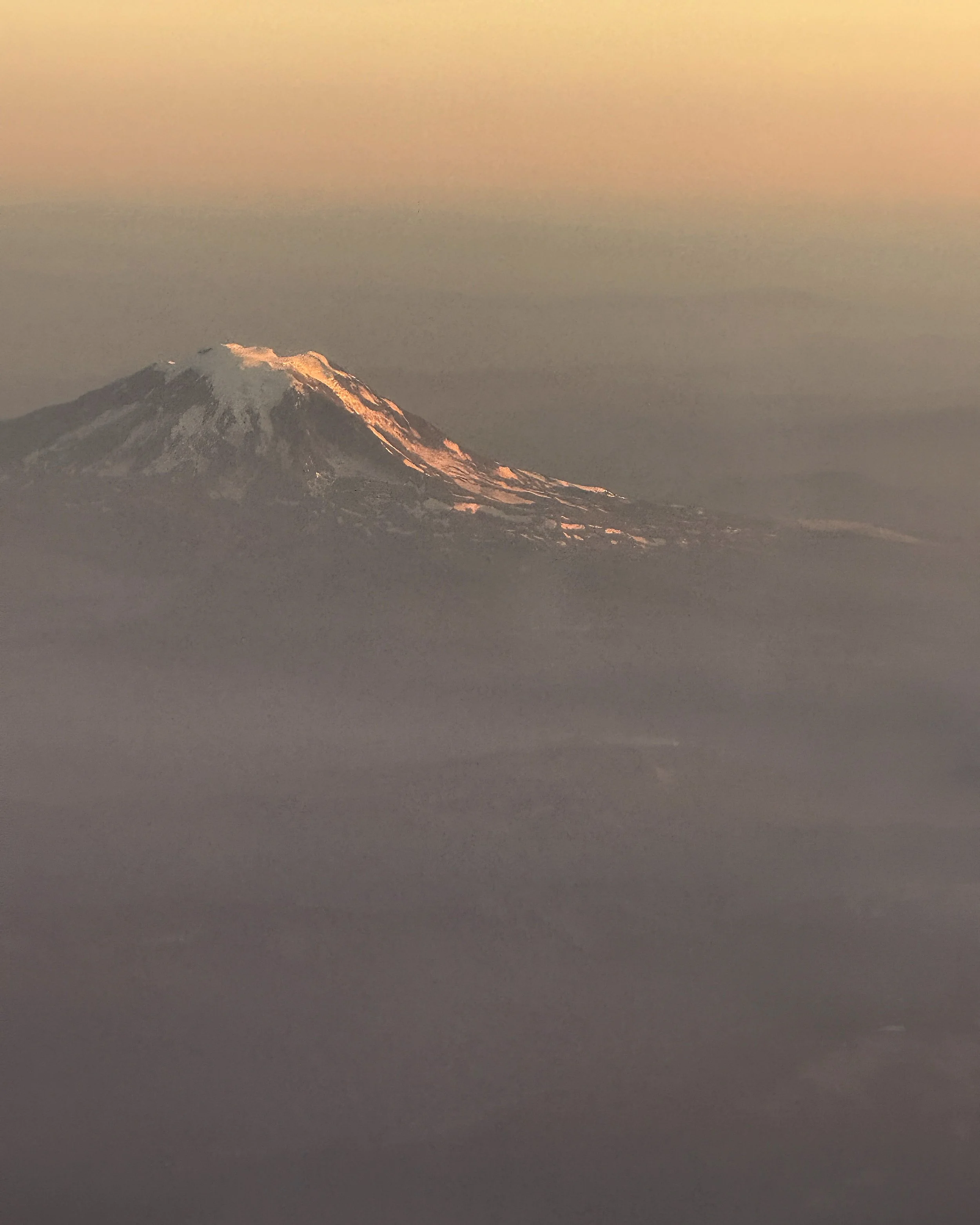
Leaving the towering glaciers and wildflower meadows of Mount Rainier behind, our journey continues eastward toward another Cascade giant. As the landscape shifts from dense forests and river valleys to rolling hills and volcanic slopes, Mount Adams gradually dominates the horizon. Known for its rugged beauty and remote alpine terrain, Adams offers a quieter, less crowded experience than Rainier, making it the perfect next stop for those seeking dramatic scenery, challenging hikes, and a chance to explore the wild heart of southern Washington.
Mount Adams rises to 12,281 feet, making it the second-highest volcano in Washington State after Mount Rainier. This massive stratovolcano is located in the southern Cascades, about 50 miles east of Mount St. Helens, and is part of the Gifford Pinchot National Forest. Unlike some of its more heavily visited neighbors, Mount Adams remains relatively remote, offering expansive wilderness areas, rugged ridges, and pristine alpine lakes. The mountain is home to several glaciers, including the Klickitat Glacier on its eastern slopes, and its volcanic activity is considered dormant but not extinct, with the last known eruptions occurring roughly 1,000 years ago. Adams is also a popular destination for mountaineers and hikers, providing challenging climbs, scenic alpine meadows, and spectacular views of the surrounding Cascades.
Hiking around Mount Adams offers a mix of vibrant wildflower meadows, alpine lakes, and striking glacier views that showcase the mountain’s rugged beauty. The Killen Creek Meadows Trail is a 5-mile round-trip hike with roughly 1,100 feet of elevation gain, typically taking 2.5–3.5 hours to complete. This trail winds through expansive meadows that burst with color in summer, with views of Adams’ glaciers in the distance. Along the way, you may spot wildflowers like lupine, paintbrush, and avalanche lilies, and the trail provides a serene, less crowded alternative to the busier Mount Rainier hikes.
For a gentler option, the Takhlakh Lake Trail is an easy 2-mile loop with minimal elevation gain of about 150 feet, taking around 45–60 minutes to complete. This family-friendly trail circles Takhlakh Lake, offering one of the most photogenic reflections of Mount Adams in Washington. You will enjoy calm waters that mirror the snow-capped peak, wildflower patches along the shoreline, and abundant wildlife including birds and small mammals. Both of these two trails provide an excellent opportunity for you to enjoy alpine scenery, and capture iconic Cascade landscapes without committing to a full-day climb.
When exploring the Mount Adams area you have several excellent options for camping, each offering a different mix of amenities and access to the mountain’s trails. Takhlakh Lake Campground, located along the northern base of Adams, is a popular Forest Service campground with roughly 46 sites suitable for RVs. It features vault toilets, potable water, picnic tables, and fire rings, but does not offer full hookups, making it ideal for self-contained rigs that want to wake up to stunning views of Mount Adams reflecting in the lake. For a slightly larger and more accessible option, Trout Lake Campground provides about 40 sites, picnic tables, fire pits, and water access, but also lacks electrical or sewer hookups, so it’s best suited for RVs equipped for off-grid camping.
For RVers seeking full-service amenities, Glenwood RV Park, a privately operated campground just outside the forest boundary, is a convenient choice. This park offers full hookups with water, sewer, and 30/50-amp electrical service, along with Wi-Fi, clean restrooms and showers, and a small general store. Its location along the scenic Cispus River provides easy access to fishing, hiking, and nearby trails, making it a comfortable base for exploring Mount Adams while enjoying modern conveniences. Together, these campgrounds offer options for both rustic and fully equipped RV travel, allowing you the ability to customize your stay depending on the style of adventure you’re chasing.
Leaving the remote meadows and glacier-fed lakes of Mount Adams behind, the route turns southwest toward one of the most dramatic volcanic landscapes in the Pacific Northwest. Mount St. Helens rises sharply from the surrounding lowlands, a stark reminder of the power of nature after its famous May 1980 eruption. The area offers a unique contrast to the quiet wilderness of Adams, with visitor centers, interpretive trails, and rugged viewpoints where the story of devastation and recovery unfolds—making St. Helens is an essential stop for those seeking both adventure and insight into the living history of the Cascades.
Mount St. Helens stands at 8,363 feet and is famous for its catastrophic May 18, 1980 eruption, which remains one of the most significant volcanic events in U.S. history. Before the eruption, St. Helens reached 9,677 feet, but the explosive eruption reduced its height and created a massive horseshoe-shaped crater on its northern flank. Today, the volcano is actively monitored and serves as a living laboratory for studying volcanic activity, ecological recovery, and landscape regeneration. The surrounding Mount St. Helens National Volcanic Monument encompasses 110,000 acres of rugged terrain, offering trails through regenerated forests, lava fields, and viewpoints like the Johnston Ridge Observatory, where visitors can observe the crater, lahars, and the remnants of Spirit Lake. Its combination of scientific significance, dramatic scenery, and hiking opportunities makes Mount St. Helens a must-see stop on any Pacific Northwest RV adventure.
I have done two different previous episodes on Mt St Helens, you can easily go back and listen to those episodes. I share my story of what I remember when she blew her top and in both of those detailed episodes I talk about hikes, where to go and where you can stay, so if you have not yet been to Mt St Helens or are interested in learning more about it, please go listen to those episodes. I will have links available in the show notes of this episode over on my website at rv out west dot com.
The Fire and Ice of Washington State—the volcanic giants of the Cascades—have shaped not only the landscape but also the culture, ecology, and sense of adventure in the region. From the icy glaciers of Mount Baker and Rainier to the smoldering, regenerating slopes of Mount St. Helens, these mountains tell stories of power, resilience, and transformation. They feed rivers, create fertile valleys, and offer habitats for diverse wildlife, while also drawing outdoor enthusiasts, photographers, and nature lovers from around the world. Each volcano carries its own character: Baker’s snowfields, Rainier’s iconic presence, Adams’ rugged solitude, and St. Helens’ dramatic rebirth—all of them contributing to the unmatched beauty and dynamic spirit of the Pacific Northwest.
There really is no better way to experience this Fire and Ice journey than by hitting the road and seeing these landscapes firsthand. Camping under alpine skies, hiking trails that wind through wildflower meadows or past glacial lakes, and stopping at interpretive centers to learn about volcanic history creates a connection that photos or stories alone can’t provide. By taking your rig and exploring these iconic mountains, you get the freedom to set your own pace, discover hidden spots, and immerse yourself in the natural rhythm of the region. Hook up your RV, hit the highways and forest roads, and let the Cascades’ fire and ice show you why Washington’s volcanoes are an adventure you should witness in person.
Next week, we’ll continue our Fire and Ice journey as we cross the border into Oregon and explore even more volcanic wonders, including the legendary Mount Hood, Newberry Volcano, and Crater Lake National Park. You won’t want to miss the breathtaking landscapes, incredible hikes, and standout RV camping spots waiting for us on the southern leg of this Pacific Northwest adventure.
Before you go, make sure you sign up for the newsletter. I’ve got something special dropping there first, and if you want to be one of the first to see it, you need to sign up now. Just use the link in the podcast description for this episode—it’ll only take a minute, and you definitely won’t want to miss the next edition. Get ready for exclusive tips, early insights, and a head start on all things RVing and volcano adventures!
If this episode sparked something in you, share it with a friend or family member who needs a little mountain inspiration in their life. And if you found value in today’s show, would you take a quick moment to leave a rating or review? You can do it right from the link in this episode’s description. It only takes a minute of your time, and it truly means the world to me. Who knows, maybe I'll share it in a future episode.
Stay tuned and don’t miss next week’s episode, where we continue the Fire and Ice journey into Oregon and explore the incredible volcanoes waiting there—from Mount Hood to Newberry and the stunning Crater Lake. It’s going to be another epic chapter of volcanic landscapes, great hikes, and RV adventure!